Well, I should have probably mentioned earlier but anyway, i had recently bought a 125cc Haojue Motorcycle, still one month old, and i’ve been riding round the island to complete the running-in period. Strange thing that the user manual says 500km run-in but the place where i bought it (dewan motors) says that run-in period is 2000km!!! I ride mostly in weekends and today i covered round 200km on the bike. This map below shows the route i’ve taken for a 4 hours’ ride!
 Unfortunately some areas of the google map where not well defined by the satellite imagery, but anyway, i’ll be defining them more clearly further below…
Pointe D’esny
So, the first picture-taking stopping point was actually at Pointe D’esny with a very interesting view of the South East side of the island. The sea was rather calm during this winter season and luckily it was also sunny.


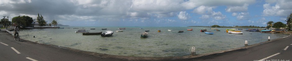
Riviere des Creoles
The journey continues and after Pointe D’Esny i reach the ‘village’ of Mahebourg, with lots of traffic and buildings everywhere… i would better say the ‘town’ of Mahebourg since i believe it should be declared ‘town’ already. I continue to ride and i reach the second bridge which was written ‘Riviere des Creoles’. I stopped to have a closer look and the river was quite nice indeed… this was also the name of the village itself – Riviere des Creoles.


Vieux Grand Port | Old Grand Port
I got on my bike again and continued to ride and after some 2km i reached the village of Vieux Grand Port. Contrary to Mahebourg, this village was rather primarily residential. Not many commercial building and it was all the way along the coast line. The view was very mountainous on the left and the sea was on the right. I reached a very interesting place which was known to be the place where the ‘Dutch’ first landed in Mauritius many years back. It was more like a monument now even though it was re-styled the modern way, which i quite didn’t like… i believe it should have been preserved the way it was at the beginning…


From this picture we can see the estuary of the river and on the complete left this is where the monument exists of when the Dutch first landed in Mauritius.


The above pictures are those of the monument itself.
Time to saddle up and after some 800m i reached another small bridge well surrounded by forest where it was all shady etc, time to relax a bit. There was another monument in that place which was somewhat more of an event commemoration than an actual place of where something happened. This monument was there to remind us actually of the introduction of sugar cane in the island by the Dutch (again) round December 1639. The monument itself was first dated November 1953…


Bois des Amourettes
The next village along this same coast-line some 1km ahead was ‘Bois des Amourettes’ and there practically wasn’t any difference in how each of them along this coast looked like, apart from their names.


Bambous Virieux
Riding again another 3.5Km i reach another region named ‘Bambous Virieux’ and i couldn’t really say much about this one either, except that near some sugar cane fields i saw some cane-cutters at work… i must say that this do look very tiring, and i wonder why there are still those traditional workers nowadays since most of the other plantations are using machines to do the job…


Pointe du Diable
I dont know if this forms part of the same village of ‘Bambous Virieux’ or not but after riding an additional 3.5km i reached an interesting place named ‘Pointe du Diable’ (Cape of the Devil?) where if i still remember my early history classes mentioned about a naval battle with canons etc… The canons are still there but unfortunately the place has been revamped to modern style somewhat… modern concrete etc. Again, i think these places should have been kept how they were and that would have also preserved the real history behind it…


Petit Sable
And the trip continues…

Grand Sable
This is what i call real ‘pied-dans-l’eau’ for this people who live just on the other side of the road, the sea is just below their window…

Grand River South East
Soon enough i was like completely on the east coast of the island and i could say that truly the east has a better weather than the west where i had been quite much previously. I had reached a region known as Grand River South East (G.R.S.E), and this river was actually known to be the longest river in Mauritius… if i still remember correctly my history lessons.I was still on the lower bank side of the river and hadn’t reached the bridge yet. I allowed myself to stray in a road which lead directly onto the river bank and to say, it was also a very wide river where small boats make it a business to carry visitors to a waterfall somewhat higher up.


Grand River South East Bridge
Time to leave the river bank and ride back to the main road. Then i reached the G.R.S.E bridge which crossed this same river and led to the other side of the river bank… and further inland now rather than coast-line.


14 Responses to 200km Trip on Motorcycle – Haojue 125